by Jonathan Wordsworth Background In early march NOSAS members helped clear part of the gorse scrub encroaching onto the major Neolithic Cairn Carn Glas (Grey Cairn NH 6493 3830) sited on Essich Farm in Stratherrick above Inverness. Sitting on...
by Jonathan Wordsworth
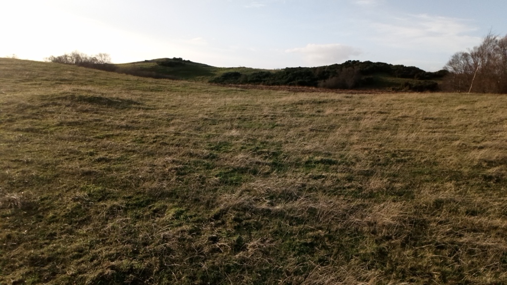
 The gorse covered mounds of Carn Glas on the skyline looking south west with a ploughed out roundhouse site in the foreground.
Background
In early march NOSAS members helped clear part of the gorse scrub encroaching onto the major Neolithic Cairn Carn Glas (Grey Cairn NH 6493 3830) sited on Essich Farm in Stratherrick above Inverness. Sitting on a shallow saddle-shaped ridge on Essich Moor and overlooking the Moray Firth to east, the three interlinked cairns that form this monument make this, at 116 metres, the longest in the Highlands. Though now obscured by a modern forestry plantation, it is in a commanding position looking down the Moray Firth. For comparison the better known and partially reconstructed Camster Long Cairn in Caithness, itself comprising two round cairns, measures just under 70 metres in length. This relative scale of the two cairns can be seen in the plans below drawn for Audrey Henshall’s Chambered Cairns of Scotland, where Camster is the second and Carn Glas the fourth image.

History of the site
The cairn lies on farm of Essich, one of the major tacks or holdings of the Mackintosh family with references to the land at least back to the 16th century.
The cairns at Carn Glas have been heavily robbed and the chambers emptied, probably as a source for stone dykes and other agricultural improvements dating to the late 18th and early 19th centuries. V Gordon Childe in 1943 suggested stones may have been taken from here to build the section of the Military Road (built from 1725) that lies to the west and runs towards Loch Ashie.
The first known mention of the cairn itself is on a sketch plan of the farm by an unknown surveyor dating to 1834. Forming part of the muniments of the Mackintosh of Mackintosh family, it is stored with other documents dealing with Essich in the National Archives in Edinburgh.
 Crown copyright. Papers of the Family of Mackintosh of Mackintosh, National Records of Scotland, RHP2187
The surveyor has probably (the text and image here are a little obscure) described the site as:
Glaischcairnmore so-called
a collection of stones on the summit of three hillocks
He has also shown three separate cairns, the easternmost and still most prominent today, is labelled Cairn. There is a suggestion of four stones ringing the middle cairn but other details are obscure. However it does seem the site had already been heavily robbed by this time. The wider plan shows the boundary of the farm defined by a row of boundary stones some of which still survive today and date to 1794 suggesting this was a time of major works on the farm when stones for dykes and buildings might be needed.
 One of the surviving boundary stones besides the farm millpond and on the edge of the modern road built over the former Military Way.
 The large T in the centre is a later OS benchmark added to the stone.
The 1834 map also shows a feature to the east of the cairn which was described as ‘an old lade’ which can still be traced on the ground and may also have used stones from the cairn. Though its full course has not been traced it appears to be taking water from the Allt Mhor flowing out of Loch Ashie to feed a mill at Essich.
 Crown copyright. Papers of the Family of Mackintosh of Mackintosh, National Records of Scotland, RHP2187
The next reference to the cairn is when Inverness Field Club visited it in May 1897 on one of their excursions and their account describes it as:
A specimen of ‘long barrow’ 120 yds long, lying east and west, and containing many empty graves of the ordinary primitive type. When this pile was in its complete condition it must have been a very conspicuous object on the top of this moorland. It has been demolished from time to time for building purposes. It formed a very convenient quarry, out of which many of the dykes and houses were built, and some were even taken to Inverness for the same purpose. Numerous hut circles and tumuli were inspected on this moor, which is quite covered with them.
Trans Inv Sci Soc v, 1897 p178The next surviving reference is not until 1943 when Professor V Gordon Childe recorded the site as part of a wartime survey and gave the first full description of the site, which can be seen in greater detail in the Canmore and Highland HER entries. He does mention an earlier booklet by James D McCulloch, Essich and its Traditions, but this has not been traced.
 Childe took the first images of the site, looking south east here (SC 1363687) and showing it as lying in a largely unimproved landscape with only a small scattering of gorse scrub and one solitary pine tree at the east end.
 SC 1363683 The chamber in the east cairn as surviving in 1943, looking east
 SC 1363686 The chamber in the westernmost cairn as recorded in 1943, looking southeast.
The site was visited by Audrey Henshall in 1957 and recorded in her magisterial Chambered Cairns of Scotland I published in 1963, largely following the description and plan of Childe.
These three cairns of the Orkney-Cromarty Group built on end along a small narrow ridge, one of a number which runs north to south across the area… The main body of the cairns is composed of naked small angular stones but the edges are overgrown and indistinct. The areas between the cairns are turf-covered but there is a low neck of cairn material below the turf connecting the cairns proper. In plan the cairns are more or less parallel sided with rounded ends. The north cairn measures 120 feet north to south and 57 feet across the chamber.
Thirty feet to the south lies the centre cairn measuring 76 feet north to south by 47 feet east to west. About thirty feet further south lies the last cairn, 124 feet long by 94 feet wide. The positioning of the chambers and the intermediate necks of cairn material suggest the cairns were regarded as a whole: the overall length is 380 feet. On the other hand, at the south end of the centre cairn there are a few earth-fast stones which suggest there may have been a peristalith of spaced stones encircling the individual cairns. In each of the cairns there is exposed part of a chamber. These all appear to be similar, rectangular in form and constructed of large flat slabs set on edge.
Though subsequently visited by OS Field Investigators, RCAHMS and Historic Scotland staff, which led to the latter scheduling the monument in 2007 as SM2392. No detailed study of the site has been made subsequently, this is probably due to the gorse covered and denuded state of the monument.
NOSAS work
A comparison of photographs from Google Earth shows the expanding spread of gorse across the site in recent years.
 Gorse cover over Carn Glas in 2005.
 Gorse cover over Carn Glas in 2022 (the diagonal line on the right of the photo is the remains of the old lade shown in 1834).
Following the successful clearance of gorse from the Culbokie henge (Teanagairn) and clearance of the settlement at Mulchaich in 2022/23, it was agreed that Carn Glas was a suitable further site for work by NOSAS. So a team of NOSAS members as well as other volunteers came out for a day’s work in early March 2023. We were particularly helped by Bruce Wilson on his chainsaw, but also by Dan Rhodes and Susan Bain from the NTS, Bob Will from HES and Arthur Macdonald and John Cheadle from Dunain Community Woodlands.


 NOSAS members at work.
 An aerial photograph was taken by Andy Hickie on his drone of Carn Glas looking north after the first stage of gorse clearance in March 2023.
Further work
It will take one, probably two, further days work cutting and the removing the cut gorse off the scheduled area and we then need to shred and remove the cut material off site, as part of our agreement with the farmer. The shredding work requires professional help and we are grateful that Historic Environment Scotland has offered funds under its Monument Management Grant Scheme and also a sum to assist in NOSAS work in completing this work, allowing this site to be properly displayed. Once this has been done we plan to do survey work on the monument and on the surrounding area which is rich in upstanding roundhouses, clearance cairns and field systems. Hopefully this will include a photogrammetric drone survey of the cairn itself and the surrounding area. Some of these roundhouses survive to almost 1 meter in height.
Help will be sought from NOSAS members in all these activities and weather permitting we are planning to remove the rest of the gorse in summer / autumn 2023. We are very keen to get as many volunteers as possible to help to lighten the work load. We are especially anxious for helpers with chainsaws, but will also need assistance from those able to drag the cut branches off the cairn and the protected area. So all can help! We may also be able to fund some equipment expenses and mileage costs for those from travelling from further afield. If interested, please contact Jonathan Wordsworth.


