
Are you planning you holiday in North Wales in 2023 and thinking about climbing Yr Wyddfa (Snowdon)? At 3560 ft (1,085 m) high it is a justifiably popular outdoor activity and can be both a real adventure and an...
Are you planning your holiday in North Wales in 2024 and thinking about climbing Yr Wyddfa (Snowdon)?
We get lots of guests staying with us at Crafnant House who come to climb Yr Wyddfa (the Welsh and now official name for Snowdon) - the highest mountain in Wales and England.
At 3560 ft (1,085 m) high it is a justifiably popular outdoor activity and can be both a real adventure and an exhilarating day out with breathtaking views, especially if you get a �cloud-free� summit!
As experienced walkers we�ve hopefully included everything you need to know in our guide about the the different paths up and down and our honest opinions on the best and most scenic routes!
We have also included helpful information and advice to help you with:
travelling to and climbing Yr Wyddfa (Snowdon) responsibly
car parking
Sherpa bus services (a great way of travelling to the trail starting points!)
facilities
when to climb Yr Wyddfa (Snowdon)
the weather
what to wear on your hike and what kit to take with you
It is worth knowing that climbing Yr Wyddfa (Snowdon) is extremely popular at the moment and the mountain can get exceptionally busy on any day.
If you are looking for a quiet, peaceful hike consider one of the many other beautiful mountains in North Wales - you are likely to have it to yourself!
View fullsize
View fullsize
View fullsize
View fullsize

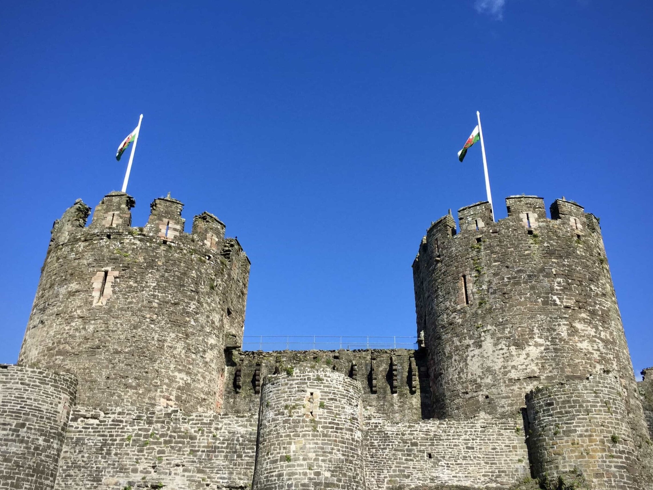
Visiting Snowdonia | Eryri?
Book Crafnant House - our boutique B&B in North Wales - here:
� �Booking direct with us saves you money!
You always get a lower rate than anywhere else!
��

On the PYG track on the way up Yr Wyddfa (Snowdon)
�The routes vary in distance and challenge level, from the (supposed) easiest to the hardest and most difficult.
It is worth reading about each one - and our preparation guide - before deciding which is the best route for you *.
In no particular order, we look at:
Preparation for your walk up Yr Wyddfa (Snowdon)
Travel and car parking
Facilities on the mountain
Environmentally responsible climbing
When is the best time to climb?
Yr Wyddfa (Snowdon) weather
What to wear and what kit to take
Fitness & training
* Please note :
These are not listed in order of difficulty - this is tricky to do as everyone has different levels of experience and abilities!
Our best advice is to read the individual descriptions below for our honest opinions on each route.
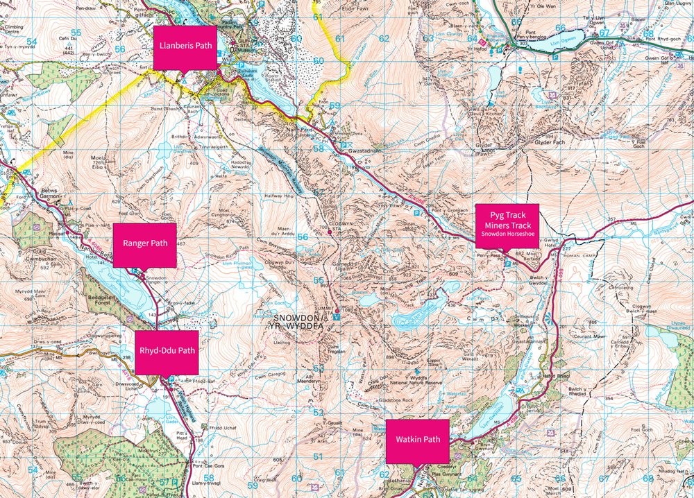
The starting points for the different routes up Yr Wyddfa (Snowdon) - the PYG Track and Miners Track are closest to our B&B! (c) OS Maps
Many of the routes can even be combined so you get a more varied, circular walk - you can use the Sherpa bus network to get back to your start point.
All of the paths are well maintained and most are generally easy to follow.
You should keep to the path at all times for both safety and to lessen the impact on the environment.
A map and compass and / or smartphone with GPS and OS maps are recommended though in case you get lost, especially in bad weather.
A torch is also useful to carry in case it gets dark and / or the weather changes considerably.
Having the right equipment and kit is a crucial part of your planning when climbing Yr Wyddfa (Snowdon) - see what we recommend below!
If you need any help planning your day on the mountain just get in touch before your stay with us at Crafnant House!
The best walking routes up Yr Wyddfa (Snowdon)
The Llanberis Path
Total distance: 9 miles (return trip)
Total climbing: 975m (3,199 ft)
How long does it take? Approximately 6 hours (there and back)
Start and finish: Far end of Victoria Terrace in Llanberis
Travel: Approximately 40 minutes / 20 miles from our B&B - Crafnant House
Car parking: A number of pay & display car parks are available in and around the village - we recommend the large one at Llyn Padarn country park / The National Slate Museum
Sherpa bus stop: Llanberis Interchange
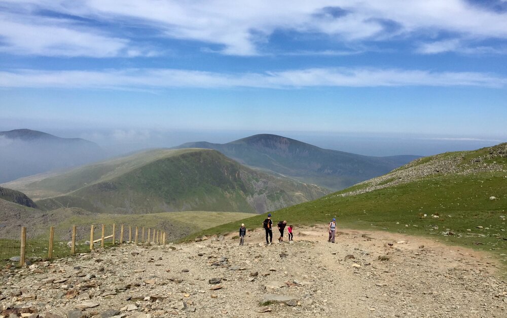
The Llanberis Path is often known as the �easiest� route to the top of Yr Wyddfa (Snowdon) and is considered to be the best for beginners - for this reason it is the most popular.
It is also the longest, starts at sea-level, and you can also see the top most of the way up which is not always the best thing if you are finding it tough.
For these reasons it is not our favourite as it can get very busy at peak times and sometimes feels like a bit of a trudge that goes on� and on�
�
The Llanberis Path
�It starts steeply from the village of Llanberis but soon eases off and then becomes a long but pleasant, gradual climb on an obvious path up to the summit, with the railway running parallel to the trail for part of the route.
Most people take approximately 5-6 hours to walk to the top and back, depending obviously on how quickly you walk.
We often then tell guests that calling it �the easiest� is not necessarily true - the �most straightforward� is probably a better description!
So we don�t say �don�t do it� - just that you might want to also consider the other routes, or combine it with one of them.
TOP TIP!
Combine the Llanberis Path with the Miners Track or PYG track!
Parking is easier in Llanberis so you won�t always need a very early start.
You could walk up this one then down one of the others (which are more scenic) before getting the Sherpa bus back to Llanberis.
Going back down the same path you walked up can be a bit boring!
2. The Miners Track
Total distance: 8 miles (return trip)
Total climbing: 723m (2,372 ft)
How long does it take? Approximately 6 hours (up and down)
Start and finish: Pen-y-Pass
Travel: Approximately 30 minutes / 15 miles from our B&B - Crafnant House
Car parking:
Small car park at Pen-y-Pass - pay and display in the winter (�10 - cards accepted) - pre-book only the rest of the year
Or use the park and ride service from nearby Nant Peris
Sherpa bus stop: Pen-y-Pass
The Miners Track was originally built to transport copper from the Britannia copper works, the remains of which are visible along the route.
The path starts reasonably flat and gentle as it winds its way through stunning lakes and scenery.
It then starts climbing significantly after Llyn Llydaw, past Llyn Glaslyn towards a rocky scree section that takes you towards the peak of Yr Wyddfa (Snowdon).
The �path� in this final section of ascent can often be unclear so take care in this area!
� View fullsize
�
It is a very good option though given the beautiful scenery and it being not too difficult!
The Miners Track is not as long as the Llanberis path and only a bit �testing� in that last third (ie. you might need your hands to support you in the steeper rocky section).
We often recommend coming back on the Miner�s Track as it is a bit easier on the knees (!) going down it, plus the last section is relatively flat which is quite nice after your climb!
TOP TIP!
Combine the Miners Track with the PYG track!
They both go from the same starting point, so do both routes (up one, down the other) and get the best variety of scenery!
3. The PYG Track
Total distance: 7 miles (return trip)
Total climbing: 723m (2,372 ft)
How long does it take? Approximately 6 hours (up and down)
Start and finish: Pen-y-Pass
Travel: Approximately 30 minutes / 15 miles from our B&B - Crafnant House
Car parking:
Small car park at Pen-y-Pass - pay and display in the winter (�10 - cards accepted) - pre-book only the rest of the year
Or use the park and ride service from nearby Nant Peris
Sherpa bus stop: Pen-y-Pass
The PYG track was rumoured to be named after the Pen y Gwryd Hostel by climbers who stayed there (including members of the 1953 Everest expedition who practised on Yr Wyddfa!)
It is slightly shorter than the Miners Track but for that reason it is much steeper and a lot more challenging.
It rises steeply straight away from the start at Pen-y-Pass and becomes quite rugged and rocky in sections.
� View fullsize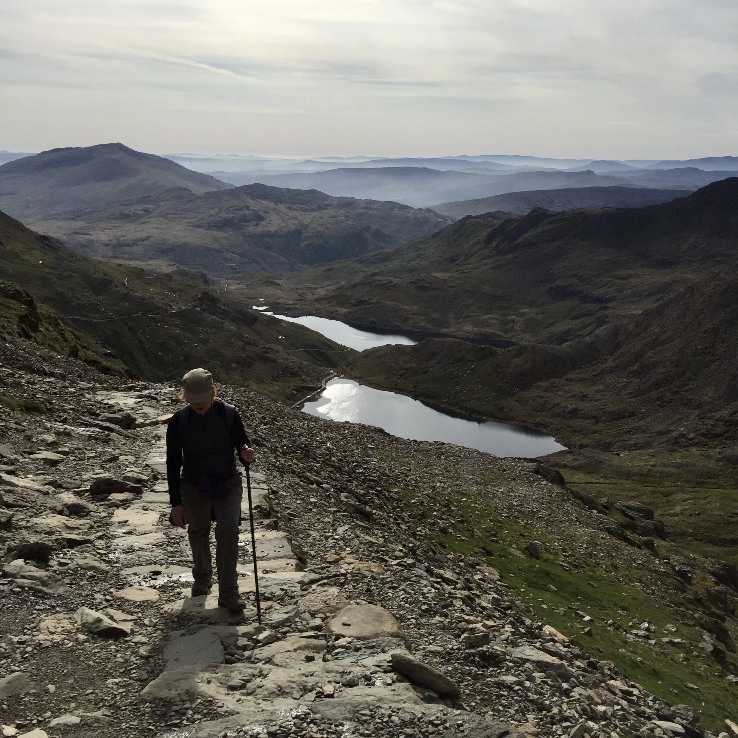
�
As compensation though you are soon above the lakes that the Miners Track snakes around.
On a clear day the views can be amazing - in our opinion it is the most scenic route with the best views.
The two paths meet each other again just before the final ascent to the summit.
TOP TIP!
Combine the PYG Track with the Miners Track - they both go from the same starting point.
We usually recommend to our B&B guests hiking up the PYG Track and going back down the Miners Track - it is our favourite combination of routes with the best views.
�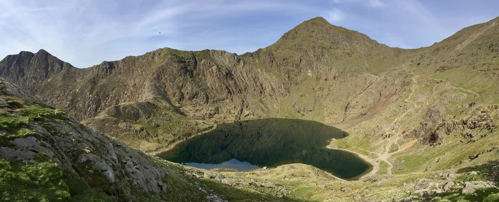
Llyn Glaslyn, viewed from the PYG track
�4. Crib Goch
Total distance: 7-8 miles (return trip)
Total climbing: 852m (2,795 ft)
How long does it take? Approximately 7-8 hours (up and down)
Start and finish: Pen-y-Pass
Travel: Approximately 30 minutes / 15 miles from our B&B - Crafnant House
Car parking:
Small car park at Pen-y-Pass - pay and display in the winter (�10 - cards accepted) - pre-book only the rest of the year
Or use the park and ride service from nearby Nant Peris
Sherpa bus stop: Pen-y-Pass
Crib Goch is not a path in its own right but a challenging diversion from the PYG Track.
It is without doubt the hardest and toughest �route� up Yr Wyddfa (Snowdon) - a grade 1 scramble that goes along a narrow, exposed knife-edge ridge.
*** WARNING ***
The Llanberis Mountain Rescue team advise that it is extremely dangerous and should not be attempted by beginners or novice walkers.
Accidents are unfortunately common every year when people fall from the ridge, sometimes resulting in fatalities.
For these reasons we don�t advise anyone to try it unless:
you know exactly what Crib Goch involves, and
you have both mountain and scrambling experience, and
the weather conditions are ideal
� View fullsize
�
You reach it by starting along the PYG Track - approximately a third of the way along there is a right turn at a stile at Bwlch y Moch for a marked path leading up to the ridge.
To avoid Crib Goch continue left at this point to continue on the PYG Track.
Once you have completed the traverse of the ridge you reach the point where the PYG Track, Snowdon Ranger and Llanberis paths converge for the final ascent to the top.
For the return trip you can take any of the others paths down, such as the Llanberis Path, PYG Track or Miners Track.
TOP TIP!
Only attempt it if the weather conditions are perfect, and - crucially - avoid it completely unless you are an experienced mountain walker
5. The Watkin Path
Total distance: 8 miles (return trip)
Total climbing: 1,015m (3,330 ft)
How long does it take? Approximately 6 hours (up and down)
Start and finish: Pont Bethania Bridge Car Park (can fill up very early)
Travel: Approximately 35 minutes / 18 miles from our B&B - Crafnant House
Car parking: Very small pay and display car park at the start - please do not park on roadside verges!
Sherpa bus stop: Nant Gwynant car park
Named after Sir Edward Watkin, an MP and railway entrepreneur, the Watkin path is on the �other side� of the mountain.
The landscape on this path has quite a different feel to the other more traditional routes.
The initial section is stunning and very scenic, taking you through picturesque woodland before hiking past numerous waterfalls, streams and pools.
� View fullsize
�
It soon becomes rocky and more challenging in the second half though, with very loose scree in places and a final steep ascent to the peak.
We consider it to be one of the hardest routes to the top of Yr Wyddfa (Snowdon), however, the first part offers beautiful scenery and is a fantastic walk even if you don�t go to the top.
NB : The Watkin Path used to be a lovely, quiet option even when the other routes were busy, however, this is no longer the case.
It is now usually exceptionally busy - some would say spoiled - due to it�s new found popularity on social media due to �attractions� in the first section such as the scenic rock pools�
Parking can now be extremely difficult at the start unless you arrive very early (please do not park on roadside verges) - why not use the Sherpa bus instead?
TOP TIP!
Make sure you are back down in time to refuel at Caffi Gwynant - a cafe located in an old chapel near the start / finish point
6. The Rhyd Ddu Path
Total distance: 8.5 miles (return trip)
Total climbing: 895m (2,936 ft)
How long does it take? Approximately 6 hours (up and down)
Start and finish: Rhyd Ddu Station Car Park
Travel: Approximately 55 minutes / 25 miles from our B&B - Crafnant House
Car parking: Small pay and display car park at the start
Sherpa bus stop: Rhyd Ddu Station Car Park
This used to be known as the Beddgelert path as it was from there that walkers used to start their hike up the mountain.
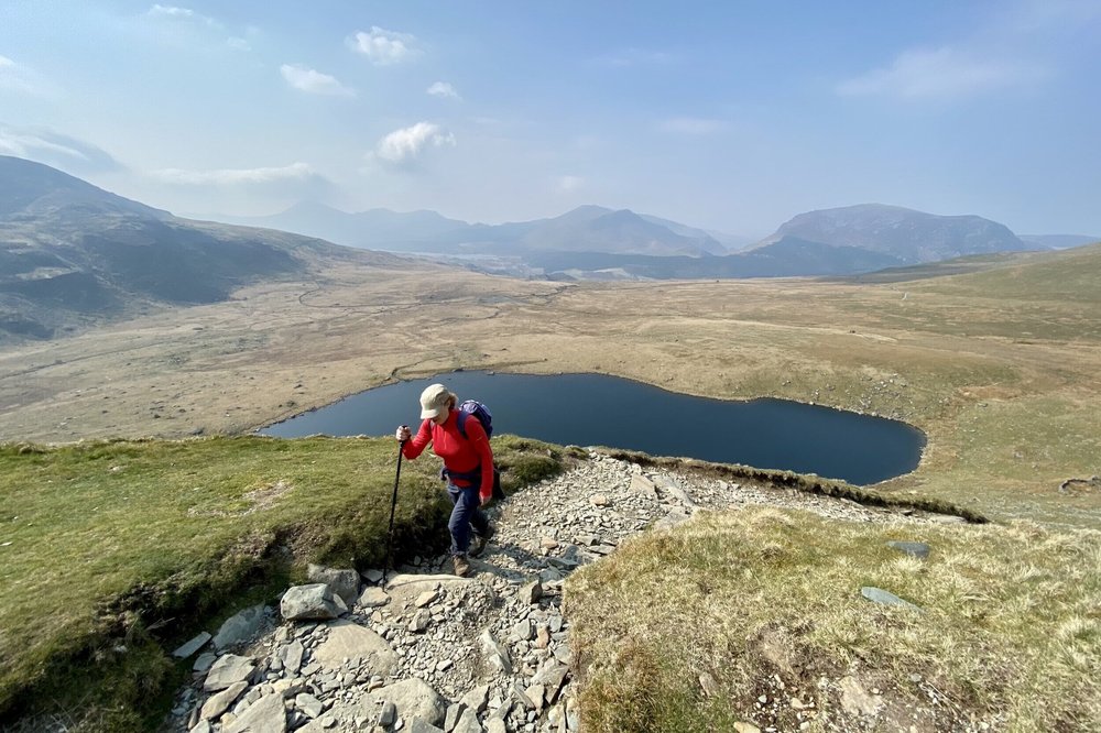
Rhyd Ddu is usually one of the quieter options so is well worth considering on those days when the more popular routes on Yr Wyddfa (Snowdon) might be inundated!
�
Jasmine and Bryn at the trig point at the summit of Yr Wyddfa (Snowdon) - it was sunny at the start!
�It is a gradual start along an old track but soon rises quite steeply, and sections nearer the summit are very rocky and narrow with steep slopes below - care should be taken in this section.
TOP TIP!
You can combine the Rhyd Ddu path with the Snowdon Ranger, and do a fantastic loop as both start and finish not that far from each other.
7. The Snowdon Ranger Path
Total distance: 8 miles (return trip)
Total climbing: 936m (3,071 ft)
How long does it take? Approximately 6 hours (up and down)
Start and finish: Llyn Cwellyn Car Park
Travel: Approximately 50 minutes / 26 miles from our B&B - Crafnant House
Car parking: Small pay and display car park at the start
Sherpa bus stop: Llyn Cwellyn Car Park
The Snowdon Ranger path begins near the youth hostel of the same name, and is thought to be one of the original routes up the mountain.
It follows a track up the slopes of the mountain on the western side before joining the Llanberis path for the final ascent to the summit.
The first section is relatively gentle, followed by some steep rocky zig-zigs, before a final ascent to the summit across sections of loose scree.
�
Stunning views on the Snowdon Ranger path
�We consider it to be one of the more straightforward routes to the top due to few rocky or scrambling sections - possibly the �easiest� after the Llanberis path?
Also it is usually quieter than the other busier paths - we did it for the first time recently and thought it was fantastic!
TOP TIP!
When you descend make sure you look out for the marker stones as the Snowdon Ranger path, Llanberis path and PYG track all go back down the same initial section
8. Preparation for your walk up Yr Wyddfa (Snowdon)
These are the essential things to know about and prepare for before you set out on your walk up the mountain.
Good planning before the day will ensure you enjoy it more, and that you go up and down safely!
Consider using a local company such as Climb Snowdon - they provide professionally guided walks and a fully supported experience.
Travel and car parking for Snowdon
Car parks at the start of each route are generally small and can fill up early in the morning, especially at weekends and in the summer
If you do want an early start we can provide a takeaway breakfast, whilst the butchers opposite our B&B in Trefriw sells excellent picnic provisions, including their famous sausage rolls!
Pen-y-Pass car park
The car park at Pen-y-Pass (for the Miners Track and PYG track) is pay and display (�10 per day - cards taken) in the winter months and pre-book only the rest of the year
65 spaces are usually available each day
Pre-booking will probably return in spring 2024 - we will update our blog as soon as we know!
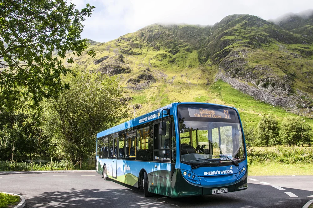
Park and ride services
Alternatively a regular park and ride service to Pen-y-Pass is also available from nearby Nant Peris which has a much larger car park
You do not have to pre-book the park and ride service
Buses ran approximately every 15 minutes on Saturdays, Sundays and Bank Holidays from 1st April 2023, and approximately every hour on weekdays the rest of the year
Other places to park
Car parks in Llanberis are more plentiful and larger, although these can also get very busy in the summer, especially at weekends
Car parks at other starting points such as those for the Watkin Path and Rhyd Ddu paths are pay and display only and fill quickly on busy days - get there early!
Don�t park on the roadside or verges, block roads or park outside of designated car parks or pay and display marked bays
Parking tickets are routinely issued throughout the national park and cars are regularly towed away if parked illegally!
Sherpa bus network & travelling by train
� �
�